Welcome to my Ars Magica Section!
This part of my homepage is dedicated to Atlas Games' fine Ars Magica roleplaying
game. It is currently in a draft stage as I begin to prepare to run a new Ars
Magica Saga, and is designed to provide a certain amount of useful information
on the Liberty of St Edmund (an area roughly equal to modern West Suffolk) in
England 1180-1240.
I shall update the page as I have time, but as this area is home to the covenant
of Libellas and the starting scenario Promises, Promises by David Chart available
from Atlas Games website, as well as being a close neighbour to the covenenants
of Nigrasaxa and Schola Pythagonaris, I shall endeavour to provide such information
as I feel may be of interest to Storyguides. It supplements David Chart's excellent
material on the town and Abbey in Heirs to Merlin, p.82-83.
As always, your saga is set in Mythic Europe not Historical Europe so if you don't like something change it or if you are not bothered by historical fact then so much the better, why let the facts get in the way of a good story? I will try and remain as historically accurate as possible on these pages however, though my own storylines may diverge significantly from the past... The important bit is to take what works for you, and discard the rest!
And finally, if you came across this page while researching for an assignment, be warned - this is material for a historical roleplaying game not an academic representation of life in medieval Suffolk! You will shortly find references to ghosts, faeries and Magi! Best try elsewhere!!!
Introduction to the Liberty
of St Edmund
Reproduced below is a fine painting of the Abbey of St Edmundsbury by a Victorian
architect, which gives you an excellent feel for the splendour of the Abbey.
When describing the Abbey as storyguide never forget that the Abbot's authority
was that of a King in the Liberty, and that he was one of the most powerful
men in England. The Abbey should provoke awe and it's ruler fear in most folk!!!
Bury St Edmunds
in the 13th Century
I offer the following map, based upon the maps in Oxford University Press fine
edition of the Chronicle of Jocelin of Brakelond. I will from time to time offer
further commentry on it for those who wish to feel they are really walking the
streets of medieval Bury St Edmunds.
For those who really do wish to do this a virtual reality model of Bury St Edmunds
and the Abbey exists, and a video tour of the town and monastery accompanied
by an excellent commentary can be bought from Bury St Edmund's Tourist Board
or the Manor House Museum. It is only about 30 minutes long, but is a perfect
introduction to the town and period for new players!!! See the cattle market
- hear the monks - gaze in awe at the Shrine of Saint Edmund!
Also reproduced there is the arms of Bury - 3 Golden Crowns on a Blue background, each with two arrows crossing through it. The heraldic symbolism all refers to the martyrdom of King Edmund in 870. In the period of Ars Magica Edmund is patron saint of England - St. George has not yet gained this honour - and his day is November 20th.
Topography and Notes on Map
The map shows the town's layout, but not the contours, so if you wish to understand
the physical layout in a 3D form print out a map (or just imagine) and fold
it in three equal vertical sections. Then lift very slighthly the right and
left thirds, so the Abbey is at the bottom of a very gentle valley (bearing
in mind the Abbey Church tower is much higher than these 'hills' and can be
seen for miles - the rise is probably less than 1 in 100, and the slopes are
no more than 70' above the valley at their highest!) Now fold the map on the
Eastgate-Wesytgate axis - there, very gentle slopes down either side of that
line towards the top and bottom of the map, except along the line of the river
valley. Then maybe consider going in to therapy for obsessive concerns with
realism in rpg! (I think I need to...OK, it's my hometown, I'm allowed to bore
you!!!)
The Rivers are the Lark and the Linnet, and even allowing for silting up since
the period they are never more than fifteen feet wide and at most six foot deep
and normally nearer two - three, so they are only navigable by rowing boats
or possibly barges. You can ford them at any point as long as you don't mind
being neck deep in water, home to a large number of ducks, freshwater fish and
leeches, the latter of which I can vouch for personally! While wading across
the river in the 1980's I managed to acquire thirty odd of the little bloodsucking
beasties which I had to burn off...
Bury was not a port, and river traffic was restricted by the Mural Bridges, mill races, etc, etc... As I discovered a forgotten Mural Bridge on the Lark just north of Bury in the 1980's, a word about them... Access to the Abbey by river is restricted by Bridges which have the walls built over the bridge on one side, and simple fortifications... The Abbott's Bridge by Eastgate Street is a fine example, I'll see if I can get a photo. There was a gate or portcullis, and the low arch meant a clearance of maybe three - five foot depending on the water level, and one assumes navigating through the Abbey to go up river would have cost a toll, and been impossible after dark when I assume the gates were closed, though they may have been guarded all night. I mention all this because I quite like the idea of running stories with a party of characters trying to punt their skiffs through the rivers and drainage channels and into the Abbey at night. The southern side of the Abbey did not have mural bridges and was probably protected by chains or maybe open to river traffic. As far as I know the Abbey had no particular concept of security, for who would dare trespass there?
To the east of the river in the Abbey grounds the Vinyards rise on a series of terraces, and a low wall (only 5') surrounds them - it was here that I went to school, gazing at the ruins of the Abbey below each day... Sorry, got carried away - the highest point is still hardly worth mentioning as a hill. I have no idea about the ditch but suspect it would have been partially water filled and a thriving patch of stinging nettles to boot, and made a fairly effective barrier to those without ReHe! Presumably plank bridges crossed it for ease of access for the monks to the fields...
Regarding the Town Wall... this was a bit of a surprise to me, as no physical trace exists today. I have no source for it other than the notes in the OUP translation of Jocelin and the map, but assume it would be 15' high, flint, and feature a walkway. The walls between the town and Abbey are about 20' and also flint (a locally occurring volcanic stone which comes in fist sized chunks and is laid with mortar. My father is a flint knapper, which is a specialised craft of breaking flint to make attractive and flat surfaces on flint walls - a speciality for East Anglian characters with the Building craft, and which also allows brittle knives and arrowheads etc to be made, as practiced in Neolithic times... Local Faeries may well have flint weaponry...) I am guessing that there was a Town Watch of maybe thirty souls, with three Sergeants commanding, and a commanding officer. In my saga they all drink in the 'Rising Sun' tavern on Risbygate St,just by the Gate Tower. Each tower probably has two - three guards on duty, armed with spear and light crossbow, and dressed in leather. They may well wear blue tabards with the three golden crowns embroidered over their tunics, but this is entirely my invention... Their primary duty would be collecting tolls and taxes off merchants and pilgrims. There would also be a small number of buildings outside each gate sheltering pilgrims and others at night who arrive after sundown, when i assume the gates would be locked. Again, no historical proof, just deduction.
Why does the wall not cover South or North East Bury? These areas are low lying water meadows, rising steeply to low hills as one moves a mile or so away from Bury. They are certainly not good terrain for armoured troops to cross except in the evry height of summer, and in winter and spring are often an inch to a foot deep in water, despite the drainage. Cattle, sheep and horses are pastured here.
Finally a few notes on the Market. The west saw cattle and animal sales, the eastern side general provisions, the south grain and corn, the north butter and dairy produce. Bury market was held on Wednesdays and Saturdays every week of the year, and would also have had entertainers and souvenir stands selling tourist bric a brac (mainly small lead badges with the three crowns of Edmund or a wolf guarding his head) to Pilgrims.
The town will be packed with taverns and inns catering to the pilgrim trade, though wealthier pilgrims might stay at the Abbey itself. It presumably had a thriving class of beggars, prostitutes and thieves who were also catering to these same pilgrims! In my saga taverns include The Fox, The One Bull and The Greyhound in Eastgate Street, The Masons and The Rose and Crown in Whiting Street, The Bushel and St. Edmund's Head in Little Brakelond, The Elephant, The Dove and The Spread Eagle in Westgate Street and the Rising Sun in Risbygate Street, but there would be many more. Northgate Street alone lacks any pubs! (and all these pubs are real and there today so have a pint if in town!). Beer is brewed by individual pubs, or bought from the monastery - then just as today you can dink the Abbot's Ale! (which is a popular brew from Greene King, an English Brewery, the label of which shows Abbot Samson so if you live practically anywhere in the UK you can buy a bottle, peel off the label, and show it to your players - whoever thought making handouts could be so much fun?...)
The Banleuca: this was the area outside the town walls, and was exempt from the privileges and protections of the town itself. I imagine it to be a rather rough and ready place filled with inns and 'colourful' characters clustered round each of the five gates...
Bury St. Edmunds and
Magna Carta
Bury St Edmunds is also where the Barons met in 1215 to discuss and formulate
the Magna Carta. It is therefore seen as the place where English Liberties were
first defended by law - hence it's latin motto which translates as 'Shrine of
a King, Cradle of the Law'. You can still see a memorial in the Abbey ruins
to the Barons who swore a solemn oath at the High Altar of the Abbey Church
to enforce the Magna Carta on King John, which that finally did at Runnymede
in 1216. I reproduce below a Victorian illustration of the Barons plotting at
the Abbey!
Justice, Administration and the Abbot
The Abbey owned a large part of the County of Suffolk, and was responsible for
admistration of approximately half of the county, an area identical to the modern
local government district of West Suffolk. This was known as The Liberty of
St.Edmund, and here the Abbot owned many rights that in other parts of the country
belonged to the King alone.
The Liberty was an area of jurisdiction; other landowners could and did own
land within it, but they were subject to the Abbot's authority - even the Sheriff
of Suffolk was powerless here. The Charter was granted by Edward the Confessor
and confirmed by Canute, whose own father was struck down by the spirit of Saint
Edmund for threatening to sack the town. Another miracle of St Edmund is described
in Heirs to Merlin p.83 and is taken from Jocelin.
During the reign of Abbot Samson the Abbey gained exemption, and the Churches within one mile, from inspection by the local diocese (Norwich, Bury did not have a cathedral till later) and the ongoing support of both Popes and Kings made Bury more important than it's small size would suggest.
To quote Greenway and Sayers (Jocelin's Chronicle, OUP, 1989, introduction p.xv) -
...the abbot acted as the King's representative... Every aspect of Royal power had to go through the abbot and his agents - whether it was execution of royal writs, the collection of taxation,or the administration of Royal Justice. Even serious criminal cases, the 'pleas of the Crown', which were normally reserved for judgement by the king's judges, belonged to the abbot. The Abbot's 'Great Court of Pleas' at Bury was the Liberty's equivalent of the King's county Court, and within the hundreds, [the liberty consisted of eight and a half Hundreds], the hundredal courts, meeting every three weeks, sat under the presidency of the Abbot's bailiff, who collected fines, taxes and other dues on behalf of both King and Abbot.
Common Law is dealt with in some detail in Chart's superb Heirs to Merlin supplement for Ars Magica (p100-107), as is Canon Law. You may also find the detailed rules on Court Cases in Ordo Nobilis useful though much of the emphasis there is on the continental and Scottish Roman Law, but the system is applicable, only the details changing... If you are running a saga which is historical enough for you to be reading this then both those supplements should be considered as priority buys. Ordo Nobilis also includes an amendment to the comabt rules regarding encumbrance which makes the game far more playable, plus much other first rate material...
The Dominion in 'Silly Suffolk'
The power of the Dominion in the liberty is obviously very high. Suffolk is
sometimes called 'Silly Suffolk'; not from the antics of it's roleplayers, but
from the Old English word selig meaning 'Holy'. Every village in this period
has at least a small wooden Church, and several have more impressive Norman
Stone buildings. Saxon Churches are wooden and have round towers, but the Norman
Churches are flint with stonework edging.
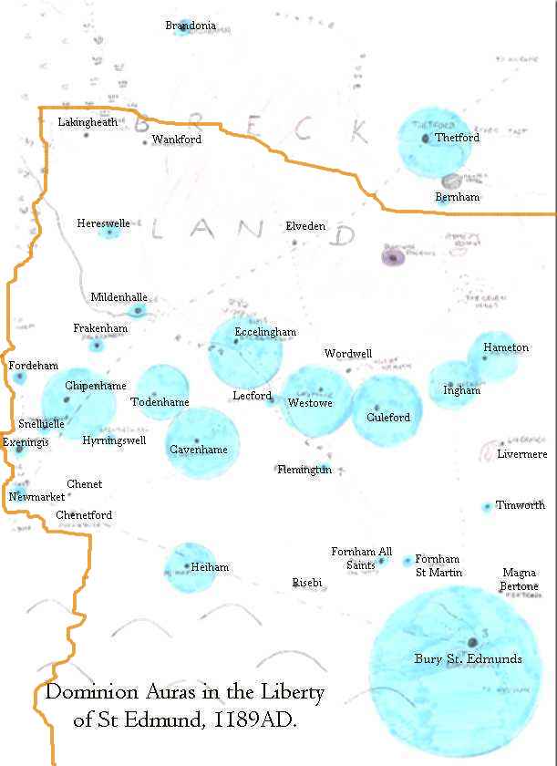
I have drawn up a map showing the rough extent and power of the Dominion around
each of these Churches, modified by the piety of the local community, areound
North West Suffolk, the opposite side of Bury St Edmunds to Libellus and Nigrasaxa.
A map of the South will follow.
The map uses the Old English place names, though Noble or well educated characters may well choose to call them by more modern forms than those shown on the map, it's your call. Where a Middle English version of the name is known I have used that... The map was adapted from an original drawn for me by Hugh wake who also carried out the research into names and churches with me, and did not scan very well, so I have retyped all place names to make them clearer!
As to scale, the distance from Bury to Thetford is 16 miles, and from Bury to Newmarket is 14 miles. Both Thetford and Newmarket have their own markets, so villages closer to them will look to them rather than Bury... The orange border represents the edge of the Liberty - land to the North is in the County of Norfolk. I apologise for the poor quality of the map and may try to redraw it later...
If you decide to use my Aura Ratings, which are based on the guidelines in Pax Dei it should be clear the Magi will suffer from some the interference a lot in their spell casting. The pale blue circles represent Dominion Aura strength, and it's reach. The totals are computed for daytime, but at night all shrink by -2 and they expand on Holy Days...
Let's run through a few examples - the delightfully named Wankford (today Wangford)has no Dominion aura: it's a tiny hamlet at a river crossing and the locals are obviously impious! (No offence to the 20th century residents!) So already we have established that it might be an interesting place... Herreswelle to the south is modern day Eriswell. The well is ancient, and there may well have been a Mercurian connection - Eris is an ancient Greek Goddess of Chaos... Anyway, the village has a typical dominion aura of one - at night it vanishes entirely, and it can only be felt round the Church and immediate environs...
Ingham is another small village, but it's Norman Church and pious people means it's aura reaches strength 2. It still vanishes at night, but travellers on the Bury - Thetford road staying here at The Boar (today the Cadogan Arms) may rest easy that it is a law abiding place. In fact easier than they might in Westowe which was an ancient Anglo-Saxon village or Culeford, both of whom have particularly effective parish priests and pious communities, and where the influence of the Abbot is strong... even at night such places have an aura of one. Thetford, home to a horsemarket and plenty of rogues, horsedealers and vagabonds is not particularly pious, but it's many Churches and the influence of the Cluniac Priory bring it up to three as well.
And so on - (I randomly generated piety levels by the way!) the size of aura is simple to calculate, just look at the relative strengths. If you've followed through my example you have got the idea by now, and probably some good ideas for stories too... Is a particualrly evangelical and militant priest responsible for the pious belt of communities to the north of Bury? Why is Risebi (Risby) so impious? Is there a secret group of Devil Worshippers there? - in the game that is!
All of the villages are real, and the map also shows the rough extent of the Fens and Breck...
Which leaves the vexed question of the strength of the Dominion in Bury St Edmunds, which must wait for my next update!
The Monastery of Saint Edmund
I reproduce here the map from the OUP edition of Jocelin, and once again encourage
you to buy it! If the Oxford University Press or Diana Greenway or Jane Sayers
objects I will remove the map, which is reproduced only for the purpose of use
in the Ars Magica roleplaying game.
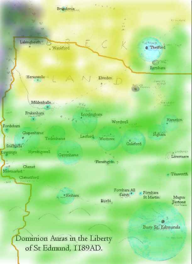
The Liberty of St Edmund: the terrain
Owing to time pressures I will simply reproduce one of my maps here for now
which shows the rough extent of Fen, Breckland and Cultivated in the NW Liberty.
The second map shows the South West liberty including the Covenant of Libellas.
I shall generate a 'dominion strength' map for this area shortly. Please feel
free to e-mail with any enquiry about the locality...
Designing Saga's in the Liberty of St Edmund
If you are starting a new saga or just want a really vivid and interesting feel
for the period then read Jocelin of Brakelond's Chronicle, which outlines the
reign of Abbot Samson. I recommend the Oxford University Press edition in Oxford
World Classics, which I based my maps upon, but you can also get beautiful translation
free off the web here...
Cut and paste the HTML version in to a word processor and you are ready to write
notes around it for a grand saga running 1180-1210, including the Palm Sunday
massacre of 1190. Excellent scope for stories, highly recommended you purchase
the Ars Magica supplement Kabbalah: Mythic Judaism to do full justice to the
potential of the town's Jewish section, which was based in Heathenman Street,
today Hatter Street. I suspect the Synagogue was in Northgate Street, and it
was there that 57 Jews were killed in the massacre... It was the second wave
of anti-semitism - in 1183 tensions rose to boiling point over a claim of ritual
murder, but the 1190 massacre marked the expuslion on pain of death of all Jews
from the Liberty (West Suffolk). Jocelin tells the story better than I could...
Saga's set in 1200 to 1220 include
all the politics of Magna Carta, and the amusing visits of King John. A canonical
(4th Edition) setting of 1220 works just as well with the information I have
provided and I am endeavouring to locate further sources on this period....