Here be Arthur, Part One: Some Notes on 13th Century Somerset & Glastonbury for Ars Magica
by Egbert of Glastonbury (Ed Woods)
Glastonbury was an island surrounded by misty swamps. Glastonbury Tor, a strangely shaped hill overlooking the town, was topped by St. Michael's church which was destroyed by an earthquake on September 11th 1275. Brent Knoll and Nyland Hill were also islands in this period, and there were many more.

The Abbey was destroyed by fire in 1184 and was rebuilt over the next century on funds generated by the claimed discovery of the tomb of Arthur and Guinevere and the subsequent 'tourism' generated as well as pilgrimage..
The regional bishopric is of what is now Bath and Wells, formerly of Bath, then of Bath and Glastonbury. Wells Cathedral (St. Andrew's) started being built in around 1180 and was consecrated in 1239. The county town was Ilchester at this time.
There were other abbeys at Athelney (founded by Alfred on the spot where he hid from the Vikings in 877 & burnt the cakes) and at Michelney (founded by King Athelstan in 950), both on islands in the swamps.
The draining of the Levels (swamps) began in the 12th century (but continued until the 18th Century) and was largely initiated by the Monks of Glastonbury Abbey.
The monks of Glastonbury Abbey caught their fish from Meare Pool a few miles to the North West of Glastonbury. Meare Pool was almost two miles across and a sizeable body of water.
As stated Glastonbury was in the middle of a huge swamp with the 1000' high ridge of the Mendips 8 miles to the north and the much smaller Poldens a couple of miles to the south. The sea is about twenty miles to the west and the land gently rises to the east as it eventually passes through the great Selwood, a forested area seventy miles and sixteen miles wide long stretching from close to Bristol to almost the South Coast. It is being deforested and has been shrinking since the Saxon period at least. Beyond the Selwood lay Salisbury Plain, with it's famous Stonehenge Monument from which the tribunal takes it's name.
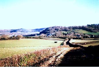
Looking from Lollover Hill across what would
have been marsh at Dundon Hill (foreground) and the Poldens. Dundon Hill would
have been a an island.
The Levels are low lying swampy ground, partially dry in Summer and completely flooded in Winter, and prone to be covered by any high tide from Bridgwater Bay. When not tidally filled they are often a freshwater lagoon full of swamp plants such as rushes, which can be cut and cultivated. Cattle are kept in the watery meadows and driven along Droves, cattle roads which are passable at low tide or the height of Summer.
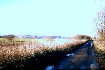
A Drove in the Levels
In Winter dense freezing fogs often blanket the Levels. The climate is temperate, with large amounts of both sunshine and rain, and snow is largely confined to the hills ad island tops.
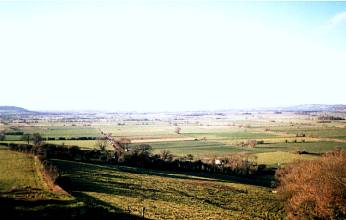
Looking from Lollover Hill across what
is today Sedgemoor towards
Bridgwater. In 13th Century this would be marsh!
Ash & Willow are common trees in the area, and willow is used to weave baskets or furniture and even make fences. There are also many orchards of apple trees, and the local cider 'Scrumpy' is renowned for it's intoxicating properties. It is many times more potent than medieval beer or even other ciders! There are cave systems in the Mendips at Cheddar and Wookey, the latter having been home to a famous witch.
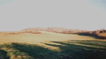
Lollover Hill, once an island.
The lead mines have been in use since before Roman times and are still in use and are open cast, that is pits in the earth not mines in the sense one normally thinks of them today, and are near Charterhouse and Priddy mainly.
Most transport was by boat although were various tracks through the swamps and the Pilgrims Way ( roughly the route of the present A39) ran east-west along the Poldens to the south of Glastonbury. The sea occasionally lapped at the western side of Glastonbury Tor during high tides due to a lot of the Levels being below sea level. There is a 12th century castle at Taunton which has origins going back to Saxon times. The castle at Castle Cary was a ruin by the late 12th century. In the far south there is Forde Abbey near Chard.
Some Holy Legends
The area around Glastonbury is well known for it's legends of Joseph of Arimathea, the wealthy merchant who gave his tomb for the burial of Our Lord Jesus Christ, and who some say was His uncle. Joseph was a trader and traders from the Levant bought Mendip lead and copper and Cornish tin from the locals in ancient times. Some say Christ accompanied his uncle here, giving the local saying 'As sure as our Lord was in Priddy'.
Chalice Well at the foot of the Tor is supposedly the place where Joseph hid the Holy Grail in one of his later visits.
Several miles across the swamps is Cadbury Castle, a hill fort occupied in pre-Roman times, refortified in the 6th century and reputed to be Arthur's Camelot. Brent Knoll, another dome shaped hill near the sea on the Bristol Channel was the supposed haunt of three giants in Arthur's time. It was also an island in the swamps known to the Romans as Mons Ranarum (the Mount of Frogs).
Joseph planted his staff in Wearyall Hill where it took root and blossomed in to the Holy Thorn, a small tree which blossoms each year on Christmas Day.
Glastonbury is not short of Saints either; a Saint Patrick is buried here, an Irishman, but not the Patron Saint of Ireland.
There are many
many more legends of Somerset which will be covered in part two of this piece.